


São Luís do Maranhão and Belém do Grão-Pará (Seventeenth and early Eighteenth century)
Rafael Chambouleyron & Alírio Cardoso
This chapter analyses the role played by the cities of São Luís and Belém in the territorial and economic expansion of the Portuguese in the Amazon region during the 17th and early 18th centuries. In colonial times, the Amazon region constituted an independent province named State of Maranhão, or State of Maranhão and Pará (see Figure 1). The French founded Saint Louis in 1612, which was afterwards conquered by the Iberians in 1615 (renaming it São Luís), invaded by the Dutch, in 1641, and recovered by the Portuguese in 1644. The city of Belém was founded by the Iberians in 1616 to the west of São Luís, at the delta of the Amazon River. One of the main characteristics shared by both cities, the existence of aquatic landscapes, had important consequences for warfare and the economic, political, and social life in the region. These special conditions were not unknown to navigators, adventurers, pirates, traders, and even cartographers, who, already since the 16th century, imagined this vast region as the limit between “Brazil,” to the East, and the “Indies,” to the West. During the union of the crowns of Portugal and Castile (1580-1640), throughout the first half of the 17th century, São Luís and Belém represented the forefront of territorial expansion.
In the first part of this paper, we will analyze the key role of both cities in the peculiar insertion of the Portuguese Amazon region into the economic, social and political construction of the Portuguese-Spanish Atlantic. This issue will be examined from three main perspectives: migration towards São Luís and Belém; their connections with other centers of the Monarchy; and proposals for commercial development or economic integration with other regions of the Atlantic. In the second part, we will address how, after securing a considerable dominion over the main (fluvial) routes and territory in the Amazon during the mid-17th century, the Portuguese expanded towards the hinterland (the sertão). This process was twofold. In the captaincy of Pará, the gathering of native Amazonian wild fruits, barks and roots in the backland, the search for indigenous labor, and the establishment of religious missions along many rivers extended the Portuguese dominions westward. This process had the city of Belém as the main center of expansion. In the captaincy of Maranhão, throughout the second half of the 17th century, the Portuguese expanded south and eastward, through conflicts against Indian groups and the spread of cattle and sugarcane. As in the case of Pará, the city of São Luís was the main nucleus of economic extension. Moreover, both cities were central for the political and military government of the vast Amazonian territory.
Figure 1 – State of Maranhão and Pará / State of Brazil
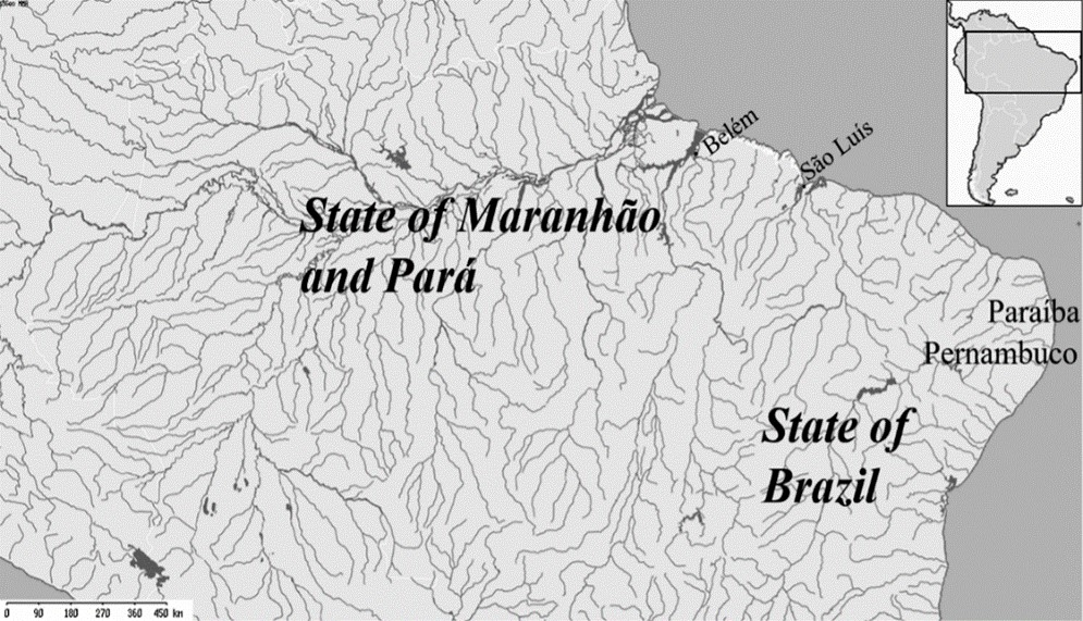
Source: Elaborated by authors using i3geo MMA (public software).
In Brazilian historiography, the debate regarding the foundation of cities in the Portuguese world seems to be based on explanatory models supported by the logic of modern-day national states (Santos, 2001; Reis, 2000; Sánchez Gómez and Santos Pérez, 2010). According to this explanation, in the Amazon region, the cities and towns founded north-west of the captaincy of Pernambuco (see Figure 1) represented the outcome of the development of peripheral economies, during the Portuguese territorial expansion along the coast, in response to foreign threats. The agents of this expansion often appear as archetypal and generic: the Portuguese conqueror, the missionary catechizer and the indigenous (labor) (Paxeco, 1912; Amaral, 1921; Meirelles, 1982). However, in recent years, we have discovered more about the complexity formation and consolidation of the first urban centers in the region, especially the cities of São Luís (captaincy of Maranhão) and Belém (captaincy of Pará). Data on population, economy, circulation of products and people, and connections with other regions can be obtained from a fragmented set of sources, not only Portuguese but also Spanish, French, and Dutch.
The first inhabitants of these urban centers were aware of the many possible connections that could link São Luís to Santo Domingo, or Belém to Bengal. Therefore, the conquest and foundation of cities in the Portuguese Amazon is, in itself, a connected history (Gruzinski, 2004). The Portuguese takeover of São Luís from the French, for example, was militarily organized in Olinda and Recife (Pernambuco), between 1613 and 1614, but its objectives were thoroughly discussed in places like Madrid, Valladolid, Seville, and Paris. Its consequences, on the other hand, were explored in English and Dutch reports. Its economic dimension was mentioned in letters from Spanish-Peruvian authorities, mainly after the founding of the city of Belém, owing to concerns about the proximity of these urban centers to the Indies of Castile (Cardoso, 2017).
There is no doubt that the cities created in the State of Maranhão and Pará represented one of the most important military events in South America at the time of the Iberian Union (1580-1640). This Spanish-Portuguese conquest embodied the new economic exchanges between Spain and Portugal. The creation of these towns consolidated the conquest of a frontier still unknown at that time. Not by chance, in 1615, the Consejo de Portugal treated the military feat based on the importance of the new lands’ geography, located “in the middle of the American dominions of the crowns of Castile and Portugal”[1] Thus, the formation of these cities cannot be divorced from the favorable setting for new colonial projects in the context of the union of the crowns. We should remember that, during this period, there was a significant increase of Portuguese agents in Spanish commercial areas. These Portuguese traders, merchants, financiers and smugglers who resided in Peru or New Spain tried to take advantage of their status as vassals of the Habsburg kings (Luxán Meléndez, 1993, pp. 127-134; Bouza Álvarez, 2000; Valladares, 2000). In 1615, the capture of Saint Louis itself was a military operation that required significant financial resources. The crowns divided the expenses. Part of the conquest was financed directly by the Spanish Crown; the other part had private resources from the military and Portuguese-Pernambuco traders, in addition to the participation of other vassals who went there as volunteers, fascinated by the reports of wealth in nearby lands (Cardoso, 2011). In fact, volunteers of all kinds, coming from distant places, were common in such military endeavors. An example was Paolo Garrafa, a citizen of the Kingdom of Naples, who, following his services in Flanders, requested to the king to be sent to São Luís as artillery captain.[2]
In Brazilian historiography, however, the creation of permanent cities in the Amazon region would be solely a Portuguese response to the “Equinoctial France” project (1612-1615).[3] However, we should consider the multiple projects that were underway at the moment. Portuguese from different regions and social strata, Spanish military and traders, foreigners from different places, missionaries, and Indians from different nations took part in this process, although not necessarily with the same interests and agenda. Allied to this, shortly after the foundation of these urban centers, there were waves of migration, including Azorean immigrants, between 1619 and 1677 (Rodrigues & Madeira, 2003).
During the period when the city of São Luís was effectively French, between 1612 and 1615, due to the agreements between General Daniel de La Touche and the Tupinambá Indians, the French built an efficient smuggling network of local products, which even attracted the attention of Dutch agents.[4] From São Luís, the French negotiated for tobacco, pepper, cotton, and dyestuff in Europe, obtained from areas close to the city of São Luís, and using routes unknown to the Spanish.[5] Like the Portuguese and the Spanish, the French were used to long-distance connections. At the same time, they had commercial activities in other areas of the Atlantic besides Guyana, from the Mississippi River valley to the Antilles, forming an important counterpoint to the Spanish Monarchy (Eccles, 1972; Parrott, 2006). Owing to the French experience in the region, Portuguese and Spaniards had sufficient information on the route between the city of São Luís and the Amazon River delta, crucial for the later founding of the city of Belém.[6] In fact, Daniel de La Touche was considered one of the only Europeans specialized in that type of river navigation, which constituted unknown routes to the Portuguese and Castilian sailors.[7]
Years later, the route between São Luís and Belém turned into a short course, which sometimes included a stop at Tapuitapera (current city of Alcântara) and later at the Indian village of Maracanã (see Figure 2). The most experienced navigators knew that the indigenous canoe – a smaller ship, better adapted to river channels – was the only effective means of transportation in many of these crossings. This is made explicit in a manuscript from the beginning of the 17th century, which stated that the best transport between cities were the “barcas llamadas canoas [the so-called canoe ships].”[8] In São Luís, the city Council regulated all issues related to the route between São Luís and Belém, establishing what type of vessels could transport people or goods, what types of goods were transported, and their respective weight (Corrêa, 2011, p. 130). In 1656, for example, the local authorities of São Luís ordered that boat masters should not leave without first informing the officials about the income from these crossings.[9]
Figure 2 – Rivers surrounding Belém and São Luís
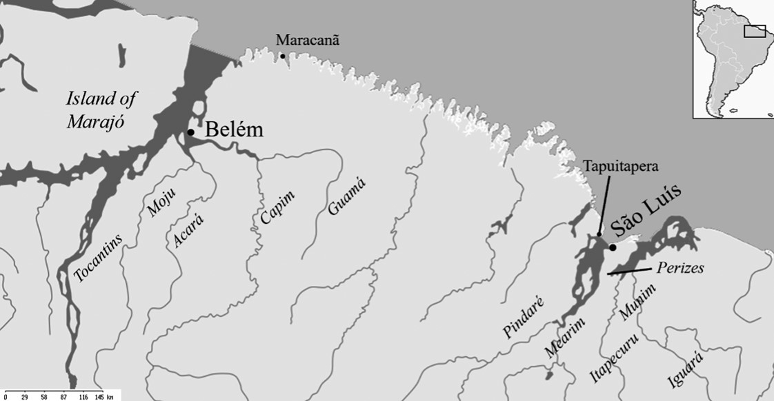
Source: Elaborated by the authors using i3geo MMA (public software).
Throughout the first decades of the 17th century, several Portuguese lived in one city and had businesses in the other. In fact, there were cases in which the city councilors of São Luís did not reside there, preferring to manage their business directly in the neighboring cities and towns of Pará. The council registrar records delays in the meetings due to the absence of councilors, who spent several months taking care of their sugar mills outside the city.[10] The navigability conditions between the two urban centers motivated commercial projects of all kinds. In 1648, residents of both cities spoke openly about constructing shipyards to build galleons or caravels, thus meeting the demands of the Carreira das Índias and taking advantage of the depth of the ports in São Luís and Belém.[11] Some projects were even encouraged by the difficulties in terms of defense, such as the idea of changing the location of the city of Belém itself in the mid-1640s, as it was considered too vulnerable to piracy.[12]
As we said, the two main cities in the region, following a well-known Portuguese occupation formula, were also port structures. For this reason, French, English and Dutch navigation through these waters had always justified several proposals to strengthen its security.[13] Some of these proposals were related to the newly discovered spices, above all, clove bark (Dicypellium caryophyllaceum (Mart.) Nees) and pixurim nuts (Laurus Pixuri).[14] In the 1650s, many sources claimed that the Dutch were interested in settling too close to the Portuguese Amazon towns in order to exploit these resources. One of these projects would be led by Dutchman Gijsbert de Witt, former governor of Paraíba (Figure 1), in the State of Brazil, between 1644 and 1645. The idea was to form fortified towns or ports on the route between São Luís and Belém, taking advantage of the large number of islands in the region.[15] Similar information motivated the fortification of pre-existing cities and towns in the Amazon.
For the Dutch, Amazonian towns were essentially indigenous urban centers that revolved around the trafficking of local products. We must remember that the city of São Luís was governed by the Dutch between 1641 and 1644. The Dutch style of domination was especially feared by the Spanish and Portuguese due to the efficient incorporation of natives into the process (Klooster, 2016; Hulsman, 2006). In the midst of the Dutch rule of São Luís (1641-1644), Pieter Janssen Bas, one of the commanders based on the city, carried out a census. The counting recorded just over 700 Europeans —soldiers and residents— and more than a thousand allied Indians, whom the Dutch called Brazilianen.[16] Regarding Belém, data from the 1637 report by commander Gedeon Morris stated that there were about 10,000 Indians close to the city; this information, however, was never confirmed by later documents.[17]
One of the motivations for the formation of new urban spaces in the Amazon was integrating these cities to pre-existing commercial circuits. This idea is supported by many sources. In 1626, for example, a resident of the city of São Luís sent an ambitious project to the Spanish court, which included the establishment of a new city. The Portuguese Simão Estácio da Silveira intended to integrate São Luís and Belém into the circuit of the Spanish Indies. His idea was to create a new fluvial route to transport local goods from the Amazon River to Havana (Cuba), protected from the piracy of the Caribbean Sea. This new route, the captain argued, would be much more efficient and cheaper compared to the already known sea routes. To this end, Silveira requested the King’s permission to create a new town. The new urban nucleus would be located somewhere along the Amazon River, with 500 inhabitants of Azorean origin and a fort protected by 200 soldiers. Although it never succeeded, this project is a good example of what the Portuguese thought at the time about the relationship between the exploration of the hinterlands, the routes, and the role of cities in the imperial context. These potential urban centers would be necessarily connected to a chain of overseas processes, experiences, and expectations.
From the second half of the 17th century onwards, when the colonization of the Amazon region became arguably consolidated, the cities of Belém and São Luís preserved their importance in the territorial expansion of the Portuguese dominions. The role played by both cities was not limited to their surroundings or juridical limits (Fonseca, 2011, pp. 26-31). On the contrary, both had what could be defined as an enlarged spatiality, which projected them into the vast hinterland – the sertões.
From the late-19th century onwards, Brazilian historiography consolidated an opposition between the coast (litoral) and the hinterland (sertão) as a reading key for the birth of the nation (at that time, the passage from a monarchy to a republic). Basically, the litoral represented the modern and urban part of the nation, connected to the civilized world through the seas; whereas the sertão was the rural backward of civilization, yet more genuinely “Brazilian” (Souza, 1997; Amado, 1995; Oliveira, 1998; Lima, 1999; Sterling, 2008). Scholars projected this understanding to the colonial past and to the entire territory of what was then called Portuguese America.
However, we should not generalize the opposition between litoral and sertão to all provinces of Portuguese America. In fact, São Luís and Belém cannot be understood but through the hinterland, even if they were both located on the coast. At the same time, they were closely connected to the Atlantic and Europe through trade and migration.
Exemplary of this double territorial dimension of São Luís and Belém are two commercial transactions that took place in the late 17th century in São Luís. The first occurred in the city council, in 1689. Diogo Fróis de Brito, a sugar mill owner from the Mearim River, bought six slaves “distributed by the council for the production of sugar.”[18] In the second transaction, a few years later, Fróis de Brito paid almost 1,5 million réis for nine slaves.[19] These captives acquired by the mill owner, however, were from a completely different origin and condition. In fact, the first six slaves – Cunhapuis, Coruru, Julia, Curibere, Catarina and a “nameless Indian” – came from the hinterland of the Amazon region, thousands of miles to the west of São Luís. The latter nine slaves – whose name, unfortunately, we ignore – came from the east, probably from the Guinea Coast, also thousands of miles from the city, brought by slave ships through the Atlantic Ocean. Cunhapuis and her unfortunate companions were taken by the ransoming troop of Francisco Ferreira Bernardes in the sertão of the captaincy of Pará; the nine Africans, by the master Manuel Luís de Macedo in his vessel Nossa Senhora da Conceição e São João Batista. Thus, at the end of the 17th century, native and African slaves met in the city of São Luís, traded by a businessman who would take them to work in his sugar mill, named Nossa Senhora da Conceição, located not in the city but in its surrounding sertões of the Mearim River (see Figure 2).
The case of sugar mill owner Fróis de Brito calls our attention to the close relationship established between the coastal cities of Belém and São Luís, and the sertões of the State of Maranhão and Pará, especially from the second half of the 17th century onwards. This connection can be understood from a different set of relations tied to 1) agropastoral expansion; 2) the settlers’ mobility; 3) economic activities in the hinterland; 4) the economic and political government of the religious orders; and 5) wars in the sertão.
In the surroundings of Belém and São Luís, an agropastoral zone began to emerge from the second half of the 17th century. The governors performed systematic land distributions (called sesmarias) among the settlers, especially on the late 17th century, when the Amazonian colonial economy began to expand (Chambouleyron, 2010; Arenz & Matos, 2014). This expansion was coordinated from both cities, where governors alternatively resided.
In the captaincy of Pará, settlers cultivated foodstuff, mainly manioc, beans, and cacao. Since the late 17th century, the Crown sponsored the cultivation of cacao orchards in Pará. Although the Portuguese already exploited this plant, especially by gathering wild fruits in the hinterland (as we will examine), cacao cultivation thrived from the 1720s onwards owing to the boom of cacao prices. The rivers Tocantins, Moju, Acará, Capim and Guamá (and their tributaries) were gradually occupied by sesmarias (see Figure 2) (Chambouleyron, 2019). In the case of the captaincy of Maranhão, the main locus of territorial agropastoral expansion was found in the Itapecuru and Mearim rivers (see Figure 2). Contrary to the case of Belém, Maranhão’s expansion implied a violent offensive against Indigenous peoples – labelled corsair Indians (índios do corso) –, which lasted from the late 17th to the mid-18th centuries. A series of wars were launched from São Luís, in order to “disinfect” the territory, as stated by the authorities (Melo, 2017; Roland, 2017). The destruction and enslavement of Indian communities preceded the arrival of sugar and cattle, which spread towards the southeast of the captaincy.
The expansion of this agropastoral frontier was closely linked to both cities. It was coordinated by the governors of the State, who resided alternately in São Luís and Belém (Santos, 2017a). Contrary to other parts of Portuguese America, in the State of Maranhão and Pará, governors concentrated land grant concessions (Alveal, 2007). Sesmarias, thus, had also a political meaning, and favored the elites of colonial cities. The inhabitants of Belém and São Luís had their lands in the closer hinterland and resided both in the cities and in their lands, as mentioned before.[20] Mobility was central here. In 1685, Judge Antônio de Andrade e Albuquerque explained the difficulties of collecting the goods of those who died or were absent from the land, since the inhabitants of Belém lived “in their lands and in the sertões, many leagues away from this city.”[21] Years later, in 1705, one of the representatives from the city council of São Luís did not vote, since he was “absent in his land.”[22]
Nevertheless, many of those who received and resided in their lands were sworn as municipal authorities. Those elected for the municipal council – the Senado da Câmara – represented the elite of the cities and were identified as “citizens” (cidadãos) (Bicalho, 2001; Bicalho, 2003). Although they symbolized the city, especially when serving in the council, many of them declared possessing or living in their estates in the surroundings rivers. A citizen called André de Oliveira Pinto served in the council of Belém in 1703, 1713, and 1718. Still, in 1706, he declared being a dweller of Belém and, at the same time, that he “has been living in his land for 15 years.”[23] José da Costa Leitão stated that he was a dweller (and citizen) of Belém, in whose council he served in 1725 and 1739. He even belonged to the brotherhood Nossa Senhora do Socorro, kept by the Jesuits in the city, since 1722. Nevertheless, when demanding the official confirmation of a land located on one of the tributaries of the Acará River, in 1730, he declared that he lived in his homestead there (sítio onde assiste).[24] In the captaincy of Maranhão, Captain Paulo Pires Tourinho, dweller and citizen of São Luís, had a corral in the Mearim River (1705), even though he served in the council in 1703-1704 (as judge) and 1706-1707 (as councillor). Manuel Amado da Fonseca, also dweller and citizen of São Luís, who served as judge in the council in 1708 and 1714, and was a member of the Casa da Misericórdia in São Luís, demanded a land in the Perizes, south of the Island of São Luís, in 1720.[25]
Many of those settlers who belonged to Belém and São Luís, yet lived in their estates, had also a close link with the distant hinterland. In fact, the economy(ies) of the State of Maranhão and Pará were not only developed in the sertões: they were also intimately linked to both cities. We should examine three different issues here.
The first is the organization of labor. For most of the colonial period, indigenous peoples, whether enslaved or free (although compelled to work), constituted the main source of labor in colonial Amazonia (Sommer, 2005; Guzmán, 2008; Mello, 2009; Dias & Bombardi, 2016; Dias 2019). The Portuguese captivated natives mainly in the hinterland of the captaincy of Pará (through negotiation with different Indigenous peoples, illegal enslavement, and war) and in the hinterland of the captaincies of Maranhão and Piauí (especially by war). Slaves had to be found in the distant sertões, particularly of the captaincy of Pará, such as the rivers Amazon, Xingu, Madeira, Tapajós, Negro, and many of their tributaries (see Figure 3). Expeditions to enslave Indians or bring indigenous peoples close to the Portuguese towns were organized from São Luís and Belém. Moreover, these cities constituted the distribution center of Indian slaves to owners such as the aforementioned Fróis de Brito, who bought his native slaves in the municipal council of São Luís. That was also the case of Luís Pinheiro Lobo and Felipe Santiago Vieira, both of them citizens of São Luís and owners of a corral by the Mearim River, who asked permission to bring slaves from the “sertão of the Amazon River.”[26] Geographer Eidorfe Moreira (1966, p. 40) stated that the city of Belém, located in the Amazon delta, “became the largest enslavement center of Brazil,” since canoes bringing indigenous peoples from various sertões arrived continuously in its docks.
Figure 3 – Sertões of Pará
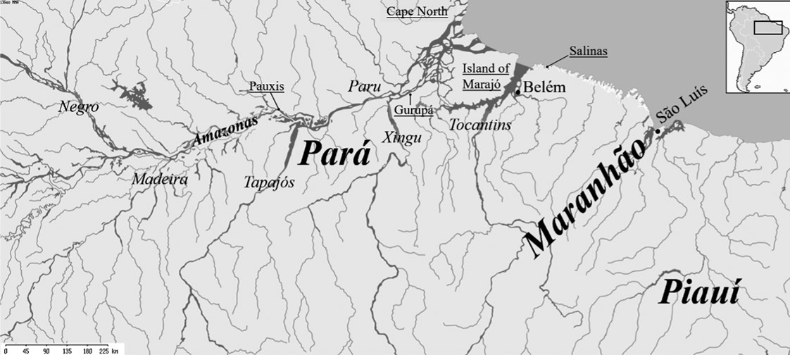
Source: Elaborated by the authors using i3geo MMA (public software).
But the Indians were not the only ones who arrived in Belém. Moreira (1966, p. 15) has already pointed out that no other region “relied so much upon a city as the Amazon region upon Belém. Everything was based on it or done through it”. Since the second half of the 17th century, an economic system that connected the city to the furthest hinterland became consolidated. In fact, the gathering of wild Amazonian fruits, barks and roots became the most important economic activity at least until the late 18th century. Cacao, clove bark, sarsaparilla and copaiba oil were collected by Indians who also rowed and guided canoes into the hinterland, via the complex Amazonian river network (Cardoso, 2015; Ferreira, 2018). These products were largely exported to Portugal through the port of Belém. Thus, canoes arriving from the sertão and ships coming from Portugal were loaded and unloaded in the docks of this city. Belém was not only a port through which these Amazonian products, known as drogas do sertão (hinterland spices), were dispatched to Europe. It was from Belém that authorities, settlers and, in a lesser extent, clerics coordinated journeys to the hinterland in search of spices (and slaves). The city, thus, became the vertex of an economic system which spread over the vast Amazon valley and its tributaries, such as the Tocantins, Xingu, Tapajós, and Madeira rivers (Roller, 2010; Pompeu, 2021). Between 1699 and 1701, the only period for which we have a systematic registry, settlers sent 226 canoes into the hinterland to collect drogas do sertão.[27]
The regular priests’ religious and economic activities in the Amazon region are exemplary of the close relationship between the cities, the agropastoral zone and the hinterland. This is notably the case of the Jesuits, who had two colleges: Santo Alexandre in Belém, and Nossa Senhora da Luz in São Luís. These institutions represented not only the religious power in the middle of the urban centers but also performed a series of other important operations in and out of the cities. The colleges were a locus of religious sociability and education, where the settlers’ sons and other clerics were educated (Chambouleyron, Arenz & Neves Neto, 2011; Arenz, 2016). The two establishments, however, were also important centers of economic government. The Jesuits had a series of estates in the same agropastoral region as the settlers: in the captaincy of Pará, fazendas on the Moju, Acará and Tocantins rivers, and in the Island of Marajó; in the captaincy of Maranhão, in the Island of São Luís (where the city was located) and on the Itapecuru and Munim rivers (Neves Neto, 2013).
But the Society of Jesus also had a network of missionary towns (aldeias) spread all over the Amazon River’s south bank (along the Tocantins, Xingu, Tapajós, and Madeira rivers), and on the main rivers of the captaincy of Maranhão (Itapecuru, Mearim, and Pindaré) (Azevedo, 1930; Leite, 1943; Arenz, 2012; Carvalho Júnior, 2017; Guzmán, 2017). The administration of these aldeias and estates was undertaken from the colleges in São Luís and Belém. Clerics and Indians commuted from the colleges to the estates and missionary villages where economic activities took place, such as the cultivation of sugar and cacao, and the gathering of the Amazonian spices in the sertão (Ravena & Acevedo Marin, 2013).
Besides their role in the functioning of economy, the cities of São Luís and Belém were crucial for the consolidation of colonial rule in the region. As discussed in the first part of this chapter, both towns became the spearhead of the Iberian conquest of the region, against other European powers and a myriad of indigenous groups. Once the conquest became consolidated, São Luís and Belém kept a role as centers for the military organization of the State of Maranhão and Pará. Governors and captain-majors commanded a network of fortresses, which increased in number over the colonial period. In the captaincy of Maranhão, until the mid-18th century, the Portuguese built forts in the city (Fortaleza da Barra, São Cosme and Damião), on the island of São Francisco, and on the Itapecuru, Mearim and Iguará riers (see Figure 2). In the captaincy of Pará, several fortresses and strongholds were constructed in the city or surrounding Belém (Forte do Presépio, Fortaleza da Barra, and the strongholds of Nossa Senhora das Mercês and Santo Antônio), along with the fortress of Gurupá (on the Amazon River, near the Xingu River) and forts or strongholds on the rivers Paru, Tapajós, Negro, Guamá; the fort of Pauxis and, in the Cape North, strongholds in the island of Marajó, and in Salinas (see Figure 3) (Viana, 2021). Although the chain of command became progressively dim with distance, Belém, São Luís and their authorities represented the base of military government of these set of fortresses. As in several parts of Portuguese America, governors held not only administrative authority, but also the military government of the State of Maranhão and Pará; that was the reason why they were sworn both as governors and captain-generals, and generally had military experience (Santos, 2017b).
The cities of the Portuguese Amazon region cannot be understood only as part of an inevitable Portuguese expansion to the north or based on formulas inspired by the current Brazilian territorial formation. Moreover, understanding them as peripheral areas of the modern Northeast Brazil’s Southern Atlantic sugar economy does not seem pertinent. After all, the cities of the Amazon were not even located in this part of the Atlantic. These were urban centers born in a frontier economy and society, which had many similarities with the old cities and towns of the State of Brazil, but also important differences. On the other hand, there was an undeniable proximity to the Spanish territory in America. The complexity of these cities came was precisely from this crossing of border references and identities.
Another issue to be considered is the appeal that the riches of the Spanish Indies, whether real or imagined, had in the Portuguese mind. In this context, although the State of Maranhão did not take part in these economic and spatial dynamics, it was geographically close to one of the most important routes of the Western world economy: the silver traffic between Peru and Seville via the Caribbean Sea. No wonder that the first settlers conceived and proposed routes and connections linking the newly founded Amazonian cities to the Spanish commercial plazas and production sites. Therefore, the border condition was never presented as a disadvantage. On the contrary, the Portuguese who lived in the Amazon region understood this particularity and created new social, political, and economic opportunities for the Portuguese population, or at least part of it.
For all these reasons, São Luís and Belém had a very diverse population in the 17th and 18th centuries. Although the majority of the white population was of Portuguese origin, there was a fluid circulation of French, English, Spanish, and Dutch people, and Indians from different peoples lived close to the cities, while missionary groups went to and from them. Moreover, these towns functioned as ports — being adapted to oceanic and fluvial daily life —, military fortress, trade hubs, political centers, religious and missionary nucleus, and even passageways to other places. These people brought with them diverse experiences and ties, connecting these Amazonian cities to other urban centers, seas, rivers, and oceans around the world.
The study of Amazonian towns leads us to a necessary reassessment of the classic historiographical opposition between the sertão and the litoral. These cities were integrated to Atlantic routes through the Atlantic islands, but were also intimately connected to the Amazonian rivers. The fluvial nature of these cities and towns was present in all activities developed by its inhabitants. Instead, the rivers in the State of Brazil, especially in the captaincies close to Pernambuco, did not have the same ubiquity, and were often considered obstacles rather than means of connection. The cities of the Amazon, on the contrary, developed not only trade but also politics, religion, and war through the rivers. Thus, we cannot strictly speak of sertão, merely as opposed to the coast or as a barrier, whether physical or imaginary, to any type of connection.
Yet, many aspects of the history of Amazonian colonial cities in the 17th and early 18th centuries remain unknown, since the analysis of their urban aspects and population has concentrated on the second half of the 18th century. We know little about everyday life, especially during the French and Dutch occupation period. We do not have much knowledge about urban indigenous peoples, who lived in Belém and São Luís, or in Portuguese towns close to them. We barely understand the spatial urban organization of both cities. We do not even know, precisely, the distribution of the social strata of the Europeans who lived there. This article is an incomplete but necessary step towards a more reliable idea concerning the complexity of the territory we know today as the Amazon.
References
Alveal, C. de O. (2007). Converting land into property in the Portuguese Atlantic world, 16th-18th century [Unpublished doctoral dissertation], Johns Hopkins University.
Amado, J. (1995). Região, sertão, nação. Estudos Históricos, 8(15), 145-151.
Amaral, José Ribeiro do (1921). Fundação do Maranhão. São Luis: Typografia Teixeira.
Arenz, K.H. (2012). Entre supressão e consolidação: os aldeamentos jesuíticos na Amazônia portuguesa (1661-1693). In S.C.C. de Almeida & G.C. de M. Silva & K.V. Silva & G.F.C. de Souza (eds.). Políticas e estratégias administrativas no mundo Atlântico. Recife: Editora Universitária da UFPE, pp. 311-335.
Arenz, K.H. & Matos, F.L.A. de (2014). “Informação do Estado do Maranhão”: uma relação sobre a Amazônia portuguesa no fim do século XVII. Revista do Instituto Histórico e Geographico Brazileiro 175, 349-380.
Arenz, K.H. (2016). “Sem educação não há missão”: a introdução da formação jesuítica no Maranhão e Grão-Pará (Século XVII). Outros Tempos, 13(21), pp. 1-20. https://bit.ly/3PqNyYy
Azevedo, J.L. (1930). Os jesuítas no Grão-Pará: suas missões e a colonização. 2nd edn. Coimbra: Imprensa da Universidade.
Bicalho, M.F.B. (2001). As câmaras ultramarinas e o governo do Império. In J. Fragoso, João, M.F.B. Bicalho & M.F. Gouvêa (eds.). O Antigo Regime nos trópicos: a dinâmica imperial portuguesa (séculos XVI-XVIII) (pp. 189-221). Civilização Brasileira.
Bicalho, M.F.B. (2003). O que significava ser cidadão nos tempos coloniais. In M. Abreu & R. Soihet (eds.). Ensino de história: conceitos, temáticas e metodologia (pp. 139-151). Casa da Palavra.
Bouza Álvarez, F. (2000). Portugal no Tempo dos Filipes. Política, Cultura, Representações (1580-1668). Lisboa: Edições Cosmos.
Cardoso, A. (2011). The conquest of Maranhão and Atlantic disputes in the geopolitics of the Iberian Union (1596-1626). Revista Brasileira de História, 31(61), pp. 317-338. https://bit.ly/3G2R2gV
Cardoso, A. (2015). Spices in Portuguese Amazon region: vegetable retail and Atlantic trade in the end of the Spanish Monarchy. Tempo, 21(37), pp. 116-133. https://bit.ly/3FSxmfv
Cardoso, A. (2017). Amazônia na Monarquia Hispânica. Maranhão e Grão-Pará nos tempos da União Ibérica (1580-1655). São Paulo: Alameda.
Carvalho Júnior, A.D. de (2017). Índios Cristãos. Poder, Magia e Religião na Amazônia Colonial. Curitiba: Editora CRV.
Chambouleyron, R. (2010). Povoamento, ocupação e agricultura na Amazônia colonial (1640-1706). Belém: Açaí.
Chambouleyron, R. (2019). Rivers and Land Grants in the Colonial Amazon Region (Late Seventeenth and First Half of the Eighteenth Century. In R. Chambouleyron & L.C. Sousa (eds.). Rivers and Shores: ‘Fluviality’ and the Occupation of Colonial Amazonia (pp. 107-131). Baywolf Press.
Chambouleyron, R., Arenz, K. H. & Neves Neto, R. M. das. (2011). “Quem doutrine e ensine os filhos daqueles moradores”: a Companhia de Jesus, seus colégios e o ensino na Amazônia colonial. Revista HISTEDBR On-Line, 11(43e), pp. 61-82. https://bit.ly/3YpxZUX
Corrêa, H. (2011). Para aumento da conquista e bom governo dos moradores. O papel da câmara de São Luís na conquista, defesa e organização do território do Maranhão (1615-1668). [Unpublished doctoral dissertation], Universidade Federal Fluminense.
Daher, A. (2002). Les singularités de la France équinoxiale. Histoire de la mission des pères capucins au Brésil (1612-1615). Paris: Honoré Champion.
Dias, C.L. (2019). Os índios, a Amazônia e os conceitos de escravidão e liberdade. Estudos Avançados 33, p. 235-252.
Dias, C.L. & Bombardi, F.A. (2016). O que dizem as licenças? Flexibilização da legislação e recrutamento particular de trabalhadores indígenas no Estado do Maranhão (1680-1755). Revista de História (USP) 175, pp. 249-280. https://bit.ly/3BDbCBM
Eccles, W. (1972). France in America. New York: Harper & Row.
Feio, D.S.S. (2013). O nó da rede de “apaniguados: oficiais das Câmaras e poder político no Estado do Maranhão (primeira metade do século XVIII) [Unpublished master thesis], Universidade Federal do Pará.
Ferreira, E.A.C. (2018). Índios remeiros e pilotos jacumaúbas na Amazônia colonial portuguesa – século XVIII. In F.A. Nunes (ed.). Nas margens do Tocantins. História, memória e ambiente amazônico (pp. 125-150). Multifoco.
Fonseca, C.D. (2011). Arraiais e vilas d’el rei: espaço e poder nas Minas setecentistas. Belo Horizonte: Editora UFMG.
Gruzinski, S. (2004). Les quatre parties du monde: histoire d’une mondialization. Paris: Éditions de Martinière.
Guzmán, D. de A. (2008). A colonização nas Amazônias: guerras, comércio e escravidão nos séculos XVII e XVIII. Revista Estudos Amazônicos III(2), pp. 103-139.
Guzmán, D. de A. (2017). La primera urbanización de los “Abunás”. mamelucos, Indios y Jesuitas en las Ciudades Portuguesas de la Amazonía, siglos XVII y XVIII. Boletín Americanista 67(2), p. 53-73.
Hulsman, L. (2006). Índios do Brasil na República dos Países Baixos: as representações de Antônio Paraupaba para os Estados Gerais em 1654 e 1656. Revista de História (USP), 154, pp. 37-69. https://bit.ly/3FVJvQV
Klooster, W. (2016). The Ducht Moment: War, Trade, and Settlement in the Seventeenth-Century. Ithaca/Londres: Cornell University Press.
Lima, N.T. de (1999). Um sertão chamado Brasil: intelectuais e representação geográfica da identidade nacional. Rio de Janeiro: Revan/IUPERJ/UCAM.
Leite, S. (1943). História da Companhia de Jesus no Brasil. Rio de Janeiro/Lisboa: INL/Portugália, vols. 3-4.
Luxán Meléndez, S. (1993). A Colónia portuguesa de Sevilha. Uma ameaça entre a Restauração Portuguesa e a conjuntura de Medina Sidónia? Penélope. Fazer e Desfazer a História, 9(10), pp. 127-134.
Martinière, G. (2011). São Luís, capitale du Maranhão, capitale rêvée de la France équinoxial. História (São Paulo) 30(1), pp. 252-263. https://bit.ly/3HCcg6c
Meirelles, Mario (1982). França Equinocial. São Luís: SECMA/Civilização Brasileira.
Melo, V.S. (2017). Cruentas Guerras: Índios e portugueses nos sertões do Maranhão e Piauí (primeira metade do século XVIII). Curitiba: Editora Prismas.
Mello, M.E.A. de S. e. (2009). Fé e império: as Juntas das Missões nas conquistas portuguesas. Manaus: EdUA.
Moreira, E. (1966). Belém e sua expressão geográfica. Belém: Imprensa Universitária.
Neves Neto, R.M. das (2013). Um Patrimônio em Contendas: Os Bens Jesuíticos e a Magna Questão dos Dízimos no Estado do Maranhão e Grão-Pará (1650-1750). Jundiaí: Paco Editorial.
Oliveira, L.L. (1998). A conquista do espaço: sertão e fronteira no pensamento brasileiro. História, Ciências, Saúde – Manguinhos, 5, 195-215. https://bit.ly/3hpXVPB
Parrott, D. (2006). France’s War against the Habsburgs, 1624-1659: the Politics of Military Failure. In: E. García Hernán & D. Maffi (eds). Guerra y Sociedad en la Monarquía Hispánica. Política, estrategia y cultura en la Europa Moderna (1500-1700). Madrid: Laberinto/Fundación Mapfre/CSIC, vol. 1, pp. 31-48.
Paxeco, Fran (1912). Maranhão: subsídios históricos e corográficos. São Luís: Typogravura Teixeira.
Pompeu, A.J.S. (2021). As drogas do sertão na Amazônia colonial (1677-1777) [Unpublished PhD dissertation], Universidade Federal do Pará.
____. (2019). Novos olhares sobre as Práticas do Sertão na Amazônia Colonial (Século XVIII). In: F.V. Santos & M.S. Ribeiro (eds). Impérios Ibéricos no Antigo Regime: governo, agentes e dinâmicas políticas e territoriais (séculos XVI-XVIII). Belo Horizonte: Fino Traço, pp. 339-358.
Ravena, N. & Acevedo Marin, R.E. (2013). A teia de relações entre índios e missionários a complementaridade vital entre o abastecimento e o extrativismo na dinâmica econômica da Amazônia Colonial. Varia Historia 29(50), pp. 395-420. https://bit.ly/3UZiuQA
Reis, N. (2000). Evolução Urbana no Brasil, 1500-1720. São Paulo: Pini.
Rodrigues, J.D. & Madeira, A.B. (2003). Rivalidades imperiais e emigração: os açorianos no Maranhão e no Pará nos séculos XVII e XVIII. Anais de História de Além-Mar, 4, pp. 247-64.
Roland, S.L. (2017). Sesmarias, índios e conflitos de terra na expansão portuguesa no vale do Parnaíba (Maranhão e Piauí, séculos XVII e XVIII) [Unpublished master thesis], Universidade Federal do Pará.
Roller, H.F. (2010). Colonial collecting expeditions and the pursuit of opportunities in the Amazonian sertão, C. 1750-1800. The Americas, 66(4), pp. 435-467. https://doi.org/10.1353/tam.0.0253
Santos Pérez, J. & Sanches Goméz, J. (eds.) (2010). De Urbe Indiana. Ensayos sobre ciudades y urbanismo en Brasil y en la América Hispana. Salamanca: Ediciones Universidad de Salamanca.
Santos, F.V. dos (2017a). Entre São Luís e Belém: um estudo da dinâmica de governo no Estado do Maranhão (1673-1751). In: E.J.S. Borges & M.H.O. Flexor & S.M. de S. S. Severs (eds.). Poderes, identidade e sociedade na América portuguesa (séculos XVI-XVIII). São Paulo: Alameda, pp. 163-188.
Santos, F.V. dos (2017b). Governadores e capitães-generais do Estado do Maranhão e Grão-Pará e do Estado do Grão-Pará e Maranhão (1702 a 1780): trajetórias comparadas. Crítica Histórica, 8(16), pp. 41-63. https://doi.org/10.28998/rchvl8n15.2017.0019
Santos, P. (2001). Formação de cidades no Brasil colonial. Rio de Janeiro: Editora da Universidade Federal do Rio de Janeiro.
Schilipake, M.F. (2020). Entre o enunciado e a prática: ocupação e organização do espaço urbano de São Luís (final do século XVII e início do século XVIII) [Unpublished master thesis], Universidade Federal do Paraná.
Sommer, B. (2005). Colony of the sertão: Amazonian Expeditions and the Indian slave trade. The Americas 61(3), pp. 401-428. https://doi.org/10.1353/tam.2005.0053
Souza, C.V. e (1997). A pátria geográfica: sertão e litoral no pensamento brasileiro. Goiânia: EdUFG.
Starling, H.M.M. (2008). A República e o Sertão. Imaginação literária e republicanismo no Brasil. Revista Crítica de Ciências Sociais, 82, 133-147. https://doi.org/10.4000/rccs.626
Valladares, R. (2000). Portugal y la Monarquía Hispánica, 1580-1668. Madrid: Arco Libros.
Viana, W.A. (2021). Gente de Guerra, Fronteira e Sertão: Índios e Soldados na Capitania do Pará (Primeira Metade do Século XVIII). São Paulo: Livraria da Física.
- “Consulta Del Consejo de Portugal al Rey de España Felipe 3º sobre la empresa del Marañon.” Madrid, 6 April 1615. Archivo General Indias [AGI], Patronato, 272, R. 3.↵
- “Sobre Constantino Paulo Carrafa”, 30 de mayo de 1620. Archivo General de Simancas [AGS], Secretarias Provinciales, 1552, fol. 290↵
- In regard the French in São Luís, see: Daher, 2002; Martinière, 2011.↵
- “Avis anonyme – Nouvelle de Portugal.” 28(?) April 1621. AGS, Estado K (de Francia) 1431, A42, n. 116-143.↵
- “Avizos tocantes à la India Occidental,” Palácio, 24 May 1615, AGI, Patronato 272, R3; “Interrogatorio dos prisioneiros francezes do combate de Guaxenduba,” 20 November 1614, Annaes da Biblioteca Nacional do Rio de Janeiro, vol. 26, Rio de Janeiro, 1905, p. 264-266.↵
- “Treslado do requerimento que fizerão alguns oficiaes e soldados desta Conquista ao capitão mor Francisco Caldeira Castellobranco a efeito, de que fosse adjunto, e collega do Capitão mor Hieronimo de Dalbuqueque.” Annaes da Biblioteca Nacional do Rio de Janeiro [ABN], vol. 26, Rio de Janeiro, 1905, pp. 206-229.↵
- “Carta del Marques de Alenquer a el Rey sobre los franceses en el Marañon,” 11 February 1619. AGS, Estado K (Francia), 1431, A2.↵
- “Declaração do que contem o Mapa dos portos do Rio das Amazonas atè à Ilha de Santa Margarida, donde se// pescão as perolas.” [início do século XVII]. Biblioteca Nacional de España, mss 3015, fol. 139.↵
- São Luís, 20 February 1656. Arquivo Público do Estado do Maranhão [APEM], Câmara Municipal de São Luís, Livro de Acórdãos, livro 3, fol. 41.↵
- 4 January 1648. APEM, Câmara Municipal de São Luís, Livro de Acórdãos, livro 2, fols. 73v-74v.↵
- Consulta do Conselho Ultramarino ao rei. February 1648. Arquivo Histórico Ultramarino [AHU], Maranhão-Avulsos, caixa 3, doc. 241.↵
- Requerimento do capitão do presídio do Grão-Pará, Manuel de Sousa de Eça. 13 January 1623. AHU, Pará-Avulsos, caixa 1, doc. 23.↵
- Consulta do Conselho Ultramarino ao rei. 18 September 1648. AHU, Maranhão-Avulsos, caixa 3, doc. 267.↵
- “Sobre as varias Experiencias q. se fizerão cõ as Especiarias E drogas do Maranhão.” 22 August 1648. AHU, Codex 14, fols. 130-130v.↵
- Consulta do Conselho Ultramarino ao rei. 23 August 1657. AHU, Maranhão-Avulsos, caixa 4, doc. 408. Consulta do Conselho Ultramarino ao rei. 11 September 1657. AHU, Maranhão-Avulsos, caixa 4, doc. 409.↵
- “Brief (kopie) van J.J. Bas, te St. Luis de Maranhao, aan gouverneur-generaal en raden.” São Luís do Maranhão, 8 April 1642. Nationaal Archief (Den Haag). NL-HaNa. OWIC 1.05.01.01. inv. n. 57(85).↵
- “Beschrijving van Maranhão, Ceará, Grand Pará en andere rivieren liggende in het stroomgebied van de rivier van Amazonas”. Middelbourg, 22 October. Nationaal Archief (Den Haag). NL-HaNA_OWIC 1.05.01.01, inv. n. 46.↵
- 9 July 1689. APEM, Câmara Municipal de São Luís, Registro da Receita dos Resgates, livro 26, fols. 3-3v.↵
- Consulta do Conselho Ultramarino ao rei. 16 November 1696. AHU, Maranhão-Avulsos, caixa 8, doc. 869.↵
- See: Schilipake, 2020.↵
- Carta de Antônio de Andrade e Albuquerque. Belém, 12 August 1685. AHU, Pará-Avulsos, caixa 3, doc. 250.↵
- 1 July 1705. APEM, Câmara Municipal de São Luís, Livro de Acórdãos, livro 7, fol. 10v.↵
- Land grant confirmed by the king on 9 December 1707. ANTT, Chancelarias Régias, Dom João V, livro 28, fols. 343-344; Feio, 2013, Appendix D.↵
- Arquivo Histórico do Tribunal de Contas, Junta da Inconfidência, n. 239, f. 16; Land granted by the governor in 6 December 1730. APEP, Sesmarias, livro 10, fols. 180-180v; Feio, 2013, Appendix D.↵
- Land granted by the king on 13 November 1711. ANTT, Chancelarias Régias Dom João V, livro 58, fols. 114v-115v; Feio, 2013, Appendices A to C. See also: Scilipake, 2020.↵
- ABN, 67 (1948), p. 118, 119-120. Land granted by the king on 6 March 1715. ANTT, Chancelarias Régias Dom João V, livro 48, fols. 334-335v.↵
- “Treslado das receitas que constaõ do livro do almoxar.do com que servio o almox.e que foi desta capitania do Parâ Luis Pereyra,” 1704. Bibliothèque Nationale de France, Manuscrits Occidentaux, Portugais 39, ff. 60v, 61, 63v, 67v, 69, 76v-77, 79v.↵

